This Tuesday we went out with a couple of friends, Dave and Carol. Carol has a 'dicky ankle', but is trying to harden it up so we took her and hubby Dave to the reef knolls of Hollingsclough. Millions of years ago, the sea lapped against the reef, and as you probably know, limestone is made up of the dead, compressed bodies of BILLIONS of minute sea creatures. It always blows my mind to try and think numbers when I see huge limestone escarpments or buttresses.
Anyway, we were really lucky with the weather (again), and we had a warm, breezy day all day. We finished off with fish and chips in the cafe at Longnor (highly recommended). Longnor used to be a very important village. It had it's own market and tolls. When rail and main roads came though, it went the way of many other 'important' places and fell by the wayside. It still sports a very worn and in bad condition toll board.
Anyway, we were really lucky with the weather (again), and we had a warm, breezy day all day. We finished off with fish and chips in the cafe at Longnor (highly recommended). Longnor used to be a very important village. It had it's own market and tolls. When rail and main roads came though, it went the way of many other 'important' places and fell by the wayside. It still sports a very worn and in bad condition toll board.
 We set off up the lovely cobbled alleyway towards the church and open fields.
 Sue & Dave chat as they walk through the flowery meadows.
 We soon crested the rise and saw High Wheeldon on the other side of the upper Dove dale.
The young river Dove goes along this valley.
 A glance left revealed our destination today. Parkhouse hill (left) and Chrome hill (right), but first we were to stop off in the village of Earl Sterndale. There was a special pub there that I wanted to show Dave & Carol.
 The quiet woman - how so, I hear you ask?.........
 Look closer.........
 After refreshment, we set off towards the reef knolls of Parkhouse hill, (on left, behind us), then Chrome hill.
This is Carol, me and Sue.

This was a real test for Carols ankle - this really is a 'knees in chest climb' up to Parkhouse hill top.
This is just one place that was made accessible by the new countryside access bill.

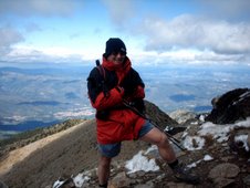
The summit party!
 Next - Chrome hill! (After a spot of tiffin, of course)
 Onward...................
 Looking back to Parkhouse hill from the flanks of Chrome hill.
You can see the path up on the ridge.
 Sue closes on the top, and gets windswept hair for her trouble.
 On top. we could see the next hill - Hollins. Yet another hill opened up by the countryside access bill. Thank GOD for it too!
We were going to walk along that top ridge, right to left, and down into the hamlet of Hollinsclough.
 And here we are - looking across the valley the opposite way. We were standing on that sharp top only an hour previously.
 The lovely lane out of Hollinsclough, and on our way back to Longnor.
That's Chrome hill there that you can see.
 Time for some well-earned fish and chips. Tuck in, Susie!
 Lastly, some of the flowers etc seen on this walk.
Thistle - closed.