We left Bakewell in the heavy mist, but with the glow of a blue sky slightly coming though. THIS was the sort of morning that showed promise! We planned to go up onto Kinder Scout, as we'd heard there was snow there last week, plus the weather man had said 'sunny all day'. I suppose we should know by now NOT to trust the weather man, but you like to believe, when it says what you want to hear, don't you? Anyway, as I said, these misty mornings usually burn off to leave that sunshine we wanted.
When we got to Castleton, it was MAGICAL! I couldn't stop up Winnats pass, so all I can do is tell you it was like a dream world, with mist rolling off edges like an ethereal waterfall. I was SO angry that there wasn't one place I could pull over, even though it wasn't busy. The best I could do was get a shot into the Hope valley when we got to the top of the climb.
When we got to Castleton, it was MAGICAL! I couldn't stop up Winnats pass, so all I can do is tell you it was like a dream world, with mist rolling off edges like an ethereal waterfall. I was SO angry that there wasn't one place I could pull over, even though it wasn't busy. The best I could do was get a shot into the Hope valley when we got to the top of the climb.
 As you can see, the blue sky was now really in evidence, and we just expected the mist to have all burned off, and be walking in the warm sunshine in no time at all.
We crested Mam Nick, and looked down into the Edale valley, which was surprisingly fairly mist-free, the only bit being at the far end of the valley?
 There ahead was our goal for today - the Kinder Scout plateau, looking good.
 A glance back to Lose hill still saw the 'misty water' flowing over the top, and into the Edale valley to dissipate in the warmer air.
 We left the car park and set off in completely the opposite direction. Because of path layouts, you have to walk WEST for a mile or so, before you can turn EAST towards Edale. Upper Booth farm is where it turns East.
 Looks like the winter store of cut wood has almost run out!
 The path to Edale is good, and in some places paved, as this is a very popular path.
You can see Kinders' southern edge on the right, and the cut of Grindsbrook.
 We also planned to go over Rushup edge at the end of the walk, but it didn't look too inviting yet, swathed as it was in mist.
 Oh well, it would probably clear later (we hoped).
This is Mam Nick, where the road cuts through from the Hope valley, to the Edale valley.
 As we walked the path to Edale, we saw this lovely poem on a bench.
To be honest, it didn't apply to us at ALL, but we thought it a nice sentiment.
 A look left showed us 'Ringing Roger' (the lump on the right) and the southern edge of Kinder.
 Here's the first thing people who walk the Pennine way see at the 'official' start - the Nags Head pub, closed this month.
 And so the climb up Grindsbrook began. The birds were singing like spring, and we even heard a woodpecker tapping rhythmically in the woods to our left. It looks like we ALL have high hopes for today!
 As usual, some interesting fungi on the fallen trees.
The first ones are the birch bracket, the second, gelatinous mass, I am not sure.
I think it's the 'Jews ear' family, judging by the colour.

 So, it was coats off, and get stuck in lass!
 Another shot of Ringing Roger, this time somehow more foreboding looking up at it.
 We had only been climbing a short while, but a look back showed us we already had appreciable height under our belts.
 There was quite a bit of water coming off the tops, and it made for some pretty waterfalls.
 Now Sue was giving it some 'grunt'. This path is very steep and rocky in places, but she wasn't complaining.
We both LOVE this type of terrain, and can't wait to get up onto the top of Kinder Scout.

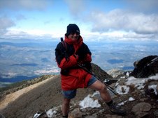
 My happy bunny!
 A lot of people would be worried by this kind of stuff, but if you take your time, you're soon up it.
 The water makes some very strange and unusual shapes, as does the wind and erosion on the top.
These 'holes' have been worn over thousands of years, beginning with a pebble, or group of pebbles that are harder than the river bed rock, being washed around and around until they wear a hole. The result is a perfect hole in the bedrock.

 And then there we were - atop Grindsbrook, and on Kinder Scout.
Now then, it's here that I should tell you about how Kinder can be a dangerous, unforgiving place.
The weather can change in an instant, and I mean an instant, so you MUST have a compass, and know how to use it, especially if you wander into the middle, where it is featureless and unrelenting peat hags. Only a fool would get lost here.
That sky is beginning to look a bit angry, don't you think?
 Anyway, after getting lost and wandering about in the middle for about 45 minutes, we decided enough was enough, set the compass and followed it south, southwest for about 20 minutes and emerged, more by luck that judgment, just where we wanted to be, the outcrop of rocks known as 'the woolpacks'.
One 'comforting' fact about Kinder is, if you DO get lost, set the compass and walk direct on a bearing, and you WILL hit the edge in less than two miles, wherever you are on the top.
Note - Sue now has her 'serious' coat on! (So did I).
 We sat down for lunch.......and THIS happened!
 As I said before, it came from nowhere, and happened in an instant! I was just glad this didn't happen when we were in the middle.
It then started to rain quite steadily, so we battened down the hatches, and decided to cut the walk short.
I had intended to take us over Brown knoll and then Rushup edge, but we dropped down Jacobs ladder as soon as we could.
The Peak park are doing some path repairs here, and it's a good opportunity to see how they helicopter in huge slabs of stone to be laid in a path to stop the serious erosion that so many boots are doing to the peat.
 We were glad, looking up, that we had decided to come down, as the gloom never lifted off the tops for the rest of the day.
It was only slightly better down here, and at least the rain had now stopped.
That ridge in the murk in front is where we should have been by now.
And a look back showed the same story up on Kinder.
 We got back to the car wet, but happy. We had 'stolen' the best part of the day, so no regrets.
Time to get home and into a warm bath.

 We got back to the car wet, but happy. We had 'stolen' the best part of the day, so no regrets.
Time to get home and into a warm bath.